Not for the Faint of Heart
Introduction
At the beginning of the 20th century the nation was feeling powerful. Mass production of automobiles in America began in the 1900s and Americans were ready to travel. They wanted freedom from the schedules and limitations of the railroads; they wanted roads to make their own way. By the mid-1920s, there were millions of motor cars registered in the nation.
Motorists were joining motoring associations and pressuring Congress to support road construction with Federal Aid Road Act funds. Touring motorists took to emerging transcontinental highways such as the Lincoln Memorial Highway, the Yellowstone Trail, and the National Old Trails Highway. The Lincoln Memorial Highway extended from New York City to San Francisco. The Yellowstone Highway reached from Plymouth Rock in Massachusetts to Seattle, Washington. The National Old Trails Highway, parts of which would later become U.S. Route 66, crossed Colorado, Arizona, and New Mexico along the Old Santa Fe Trail. Automobile adventurists welcomed highway access to far-flung reaches of the counrty, and the motor touring industry became a major industry in the western states.
Motor touring was not without its problems. The relative isolation of the west, the temperamentalness of the new automobiles, and the driving conditions on most western roads challenged the new "automobilists." Newly-formed automobile clubs, associations, and cities were all keen to help the daring. By the 1920s, the motor inn was born in response to the influx of automotive travelers.
Our selection of early-to-mid 20th century pamphlets highlights the types
of maps produced, some of the directories and services available to motorists,
and promotional advertisements for early motor inns in the Southwest.
In order to view the following files you must have an Acrobat Reader.
If you do not possess this software please consult the
About
the PDF link. To view a larger color image of one page of the pamphlet in JPEG, click on any image thumbnail. To view the whole pamphlet as PDF (color or black-and-white), click on the linked call number next to the thumbnail.
 Albuquerque Auto Trades Association
National Old Trails Highway: The Grand Canyon Route
Albuquerque, New Mexico: Thos. Hughes, Printer
Circa 1920s, 30 pp.
C9791 Pam 44 [2.7 MB]
The National Old Trails Highway is part of the original transcontinental highway made up of the old Santa Fe Trail and the Great Spanish Trail. Most of the route parallels the Santa Fe railroad line which means automobile travelers are not far from tourist accommodations and services. This pamphlet details the road log of the route from Kansas City to Los Angeles. Each town and many scenic features encountered by the motorist are described.This brochure is published by the Albuquerque Auto Trades Association. The text of this 28 page pamphlet could not be legibly reproduced here. We have shown some of the historical photos contained in the pamphlet.
 Arizona Automobile Association and Rocky Mountain Motorist Inc.
Travel Directory of Arizona
Phoenix and Denver
1931, 32 pp.
WT9791 Pam 69 Part 1 [2.3 MB], Part 2 [1.4 MB]
This 32 page brochure published by the Arizona Automobile Association invites the motorist to tour the many scenic attractions in Arizona. Travelers can enjoy the sites reached by "splendid roads which make motoring a pleasure." The booklet contains descriptions of the Grand Canyon, the Petrified Forest, Tombstone, Nogales, Litchfield, the Salt River Valley and other sites. It also has hotel, motor court, and guest ranch advertisements. Its back cover has a carrier slot for fold-up maps. We have provided the first eleven pages for your perusal.
 Conoco Travel Bureau
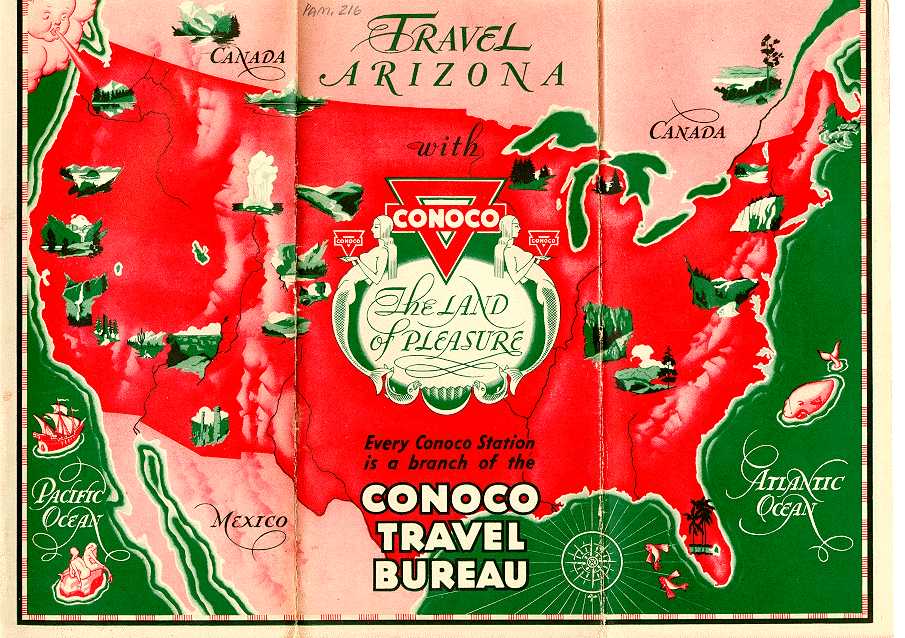
Travel Arizona with Conoco
Chicago: The H.M. Gousha Company
Circa 1930s, 1 folded sheet
C9791
216 Cover only [1.6 MB]
The Conoco Company known for its "Red Triangle - Symbol of Service" offers three fold out maps in this brochure: the Official Road Map of the United States (scale 1"= 200 miles), the Official Road Map of Arizona (scale 1"= 20 miles) and the Grand Canyon National Park map (scale 1"= 5 miles). The H.M. Gousha Company of Chicago, Illinois compiled the maps. One map is reproduced.
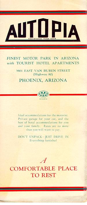 Autopia
Phoenix, Arizona
Circa 1930s, 1 folded sheet
L9791.P57 Pam. 81 [1 MB]
Autopia - "Don't Unpack- Just Drive In" is an advertisement for a commercial motor park located in Phoenix, Arizona on Highway 80. The brochure sells Autopia as "the ideal accommodations for the motorist. Private garage for your car, and the best of hotel accommodations for you and your family. Rates are no more than you will want to pay." The motor inn also offered stationary and business cards.
 Arizona State Highway Department
Arizona Road Map
Phoenix, Arizona: Eng. & Litho. Co.
1940, 1 folded sheet
C9791 Pam.
250 [1.6 MB]
The Arizona State Highway Department issued free fold-out color road maps (scale 1"= 20 miles) of Arizona each year. The cover of this pamphlet commemorates Francisco Vasquez de Coronado. An insert reads " Francisco Vasquez de Coronado, proud cavalier of New Spain, passed this way in 1540, following the ancient trade route of the Indians to the portals of the Land of the Zunis and the Seven Cities of Cibbola. Fray Marcos de Niza pointed the way." This pamphlet includes an index of cities, table of distances, points of interest, and motor vehicle regulations. The regulations are reproduced. Map drawn by W.M. DeMeres. Unfortunately the map is too large to reproduce.
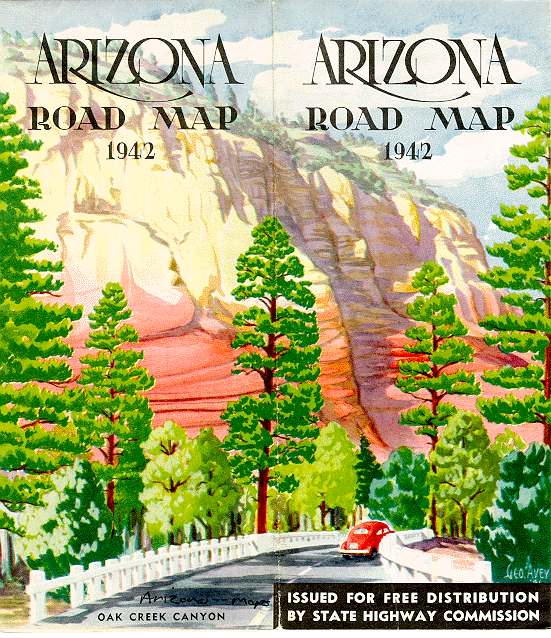 Arizona State Highway Department
Arizona Road Map
Phoenix, Arizona: Eng. & Litho. Co.
1942, 1 folded sheet
C9791 [2 MB]
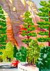
This is another example of the Arizona State Highway Department's free
fold-out color road map (scale 1"= 20 miles) of Arizona. The pamphlet
also has an index of cities, table of distances, points of interest and
motor vehicle regulations. The regulations are reproduced here. The "Do Nots" include: "Do not forget to
give proper arm signal". Map drawn by W.M. DeMeres. Unfortunately
the map is too large to reproduce.
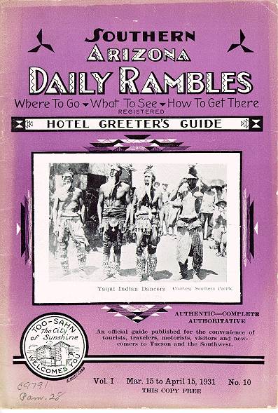 Hotel Greeters of Arizona
Southern Arizona Daily Rambles: Hotel Greeter's Guide. Vol 1.,
No. 10.
Tucson, Arizona
1931, 36 pp.
C9791 Pam. 28 [1 MB]
Southern Arizona Daily Rambles is a monthly publication containing
information about Tucson, its surrounding territory and data on current
events, for the visitor, tourist, newcomer, as well as for local
residents. It is widely distributed in Southern Arizona by hotels,
Southern Pacific Railway Company, Chicago, Rock Island and Pacific Railway
Company, taxi companies, leading business houses throughout the downtown
business district, news stands, civic clubs, tourist camps and guest
ranches. The book is the official publication of the Hotel Greeters of
Arizona, Charter No. 38, and has the sanction of the Tucson Merchants
Credit Association. Lowell J. Arnold was the publisher of this issue. We
have reproduced a few of the 36 pages of this pamphlet.
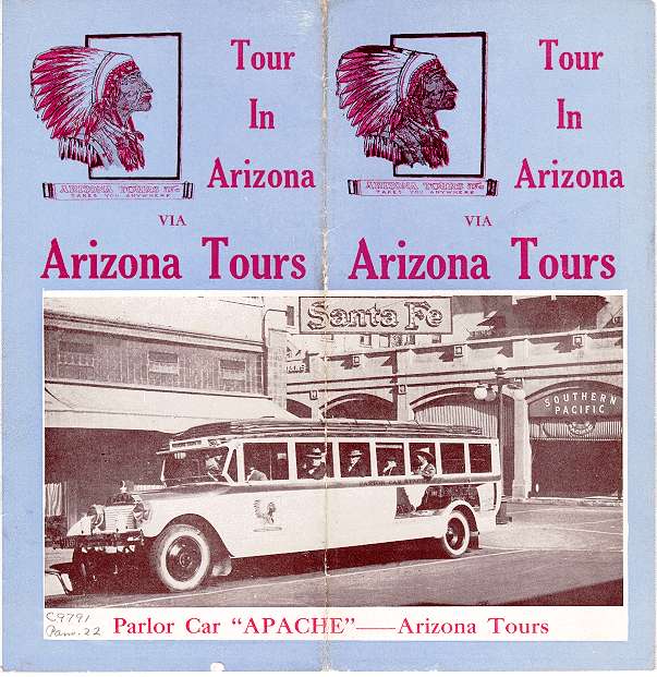 Arizona Tours, Inc.
Tour in Arizona via Arizona Tours
Phoenix, Arizona
Circa 1930s, 8 pp.
C9791 Pam. 22 [1.7 MB]
This 8-page pamphlet is a commercial advertisement for the Arizona Tours
Inc. The pamphlet highlights the standard tours that the company offers
including Canyon Lake trip, 70-Mile Valley Tour, and Roosevelt Dam trip.
The company also offered other additional personalized tours. The company
operated the "comfortable parlor car, "Apache," and a fleet
of Cadillac, Buick, and Packard sedans, with competent and careful drivers...".
 Arizona Tours, Inc.
Seeing Central Arizona
Phoenix, Arizona
Circa 1930s, 1 folded sheet
C9791 Pam. 22 [2 MB]
This fold-out pamphlet is a commercial advertisement for the Arizona Tours Inc. The pamphlet highlights the 70-Mile Valley Tour that the company offered as part of its standard tour package. The 70-Mile Valley tour went through the Salt River Valley of central Arizona. This account is written by a new arrival after taking the trip.
Introduction | Accessibility | Advertising | Agriculture | Architecture | Entertainment | Environment
Exotic | Health | Indigenous Culture | Railroads | Religion | Roads